
1,000-km cloud band shifts east, IMD issues severe hail and rain alert for Central India on Sunday
A massive atmospheric tug of war unfolded over North and Central India on Saturday, and the meteorological upheaval is far from over.
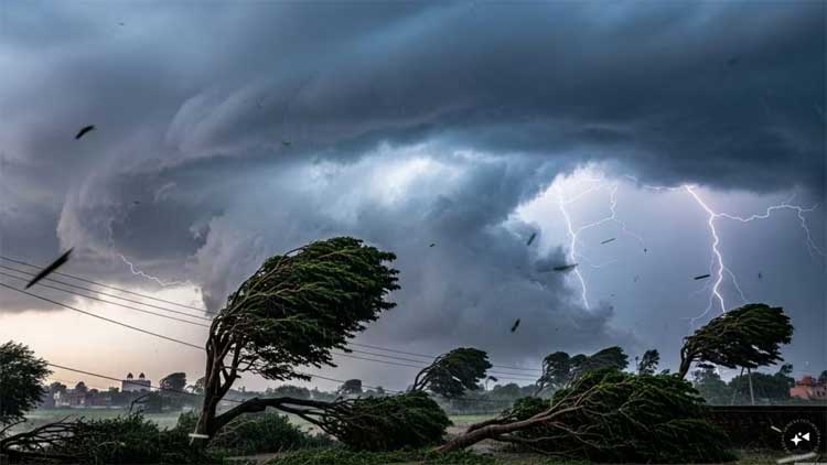
A powerful Western Disturbance has disrupted typical spring conditions, replacing early April warmth with a volatile mix of thundersqualls, intense rainfall and hail.
Parts of New Delhi witnessed a dark, wintry spectacle as a vast cloud band stretched nearly 1,000 kilometres across the region. The India Meteorological Department (IMD) has issued a yellow alert for the Delhi-NCR region, warning of continued instability.
What is driving this unseasonal rain?
The culprit is an unusually strong Western Disturbance — a moisture-laden weather system originating near the Mediterranean Sea. As it travels eastward, it interacts with warm, rising air over the plains, triggering pre-monsoon convective activity.
When surface heating causes warm air to rise rapidly, it collides with cold, moist air brought by the disturbance. This leads to the formation of towering cumulonimbus clouds — dense storm systems capable of producing sudden and intense bursts of rain, lightning and hail.
Meteorologists note that the structure of this system is particularly unusual, stretching thousands of kilometres in a near-linear formation, which explains the widespread impact across northern India.
Where is the storm heading next?
While the peak impact for Delhi-NCR and Haryana was observed on Saturday, the focus of severe weather is now shifting eastward.
On Sunday, heightened activity is expected across central and eastern parts of the northern belt, including Jhansi, Gwalior and regions of Madhya Pradesh. These areas are likely to witness strong thunderstorms and thundersqualls by afternoon or evening.
A thundersquall involves a sudden and sharp increase in wind speed, with gusts potentially reaching 60–70 km/h — strong enough to damage temporary structures and flatten standing crops. The IMD has urged residents to remain cautious.
Why is hail falling in April?
Hail formation is linked to the intense vertical activity inside thunderclouds. Powerful updrafts carry water droplets into sub-zero layers of the atmosphere, where they freeze into ice pellets. These are repeatedly lifted and dropped within the cloud, accumulating layers of ice before eventually falling to the ground.
While rainfall has brought some relief by lowering temperatures by around 5°C, hail poses a serious threat to agriculture. Recent storms have already caused crop damage in Rajasthan and Haryana.
As the system moves toward western Uttar Pradesh and Madhya Pradesh, the risk to crops remains high. Authorities have advised residents in affected regions to stay alert as the Western Disturbance continues its passage across the subcontinent.
Comments are closed.