
Climate Change, Melting Glaciers & Big Dams: Why Northeast India Faces Rising Disaster Risks

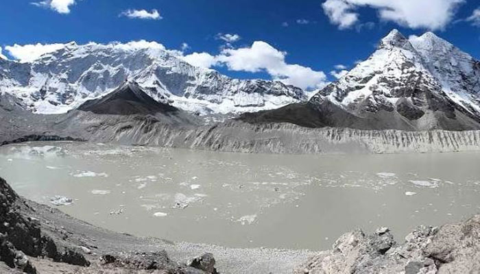
The deadly glacier-related disaster in Nepal has sounded a fresh warning for the fragile Himalayan region, raising concerns over whether a similar chain of events could threaten India’s ecologically sensitive Northeast.
The August 26 disaster near the Nepal-Tibet border sent torrents of water, mud and debris downstream, destroying homes, roads and hydropower infrastructure. More than 1,200 people have reportedly died, with thousands still missing.
The disaster has renewed scrutiny of the risks facing northeastern states such as Sikkim, Arunachal Pradesh and other Himalayan areas, where retreating glaciers, rapidly expanding glacial lakes, extreme rainfall and a growing network of hydropower projects exist within the same vulnerable landscape.
Sikkim has already seen the danger
Sikkim provides one of the clearest examples of what could happen when glacial hazards meet critical infrastructure. Authorities have identified 40 high-risk glacial lakes in the state, including 16 placed in the highest-risk Category A.
In October 2023, the South Lhonak glacial lake breached its natural barrier, triggering a massive Glacial Lake Outburst Flood, or GLOF. The flood surged through the Teesta river system and destroyed the Teesta III hydropower dam at Chungthang.
Dozens of people died, while roads, bridges and other infrastructure were severely damaged.
The disaster demonstrated how an event beginning at high altitude can quickly become a large-scale crisis downstream, particularly when settlements and major infrastructure are concentrated along narrow Himalayan valleys.
- A warming Himalaya is changing the risk
- Climate change is adding another layer of uncertainty to the region.
As temperatures rise, glaciers are retreating and meltwater is contributing to the growth of glacial lakes. Many of these lakes are held back by unstable moraine or other natural barriers. A sudden failure can release millions of cubic metres of water downstream. Heavy rainfall, landslides, avalanches and earthquakes can all act as triggers.
Unlike ordinary flooding, a GLOF can carry enormous quantities of rocks, mud and debris, making it particularly destructive as it moves through steep mountain valleys. Scientists have increasingly warned that glacier retreat and expanding glacial lakes are becoming important hazards across the Himalayas, including northeastern India.
Big dams could amplify the consequences
The Northeast is one of India’s major hydropower regions, with large projects operating or being developed across the Himalayan states. Dams do not cause glacial lake outburst floods. But when a sudden flood hits a river valley packed with hydropower facilities, roads, tunnels and transmission infrastructure, the potential consequences can be much greater.
A powerful flood could damage a dam or diversion structure, block roads, inundate tunnels and disrupt electricity transmission. Damage to one facility could then affect connected infrastructure further downstream. The experience in Nepal has highlighted this vulnerability, with hydropower installations among the facilities affected by the recent disaster.
Experts therefore stress that the safety of individual projects cannot be assessed in isolation. Entire river basins and the infrastructure networks within them need to be considered.
- The Northeast faces multiple hazards
- Glaciers are only one part of the problem.
Northeast India is already vulnerable to landslides, flash floods, extreme rainfall and earthquakes. Climate change could increase the frequency or intensity of some of these hazards and make their interactions harder to predict.
A future disaster, therefore, may not start with a GLOF. Extreme rainfall could trigger a landslide, destabilise a glacier-fed lake or damage infrastructure, creating a cascading event involving several hazards simultaneously.
Early warning could save lives
The growing risks have increased the importance of monitoring vulnerable glacial lakes and establishing reliable early-warning systems.
In Sikkim, authorities have explored measures including controlled drainage of vulnerable lakes, drainage structures, plug walls and tunnels. Satellite imagery and remote-sensing technologies can also help track changes in glaciers, lakes and surrounding terrain.
But experts caution that technology alone is not enough.
Early warnings are useful only when communities can respond quickly. That means evacuation routes, communication networks, disaster drills and resilient infrastructure must be developed alongside monitoring systems.
The bigger question: How much development can the Himalayas take?
The Northeast faces a difficult balancing act. The region has enormous hydropower potential, but its mountains are also among India’s most environmentally and geologically fragile landscapes.
Large-scale construction in steep terrain can increase exposure to landslides and floods if environmental safeguards and risk assessments are inadequate. Climate change further complicates planning because historical weather patterns may no longer accurately reflect future conditions.
The lesson from Nepal is therefore broader than the threat posed by melting glaciers.
It is about what happens when climate change, unstable mountain terrain, extreme weather, rivers and concentrated infrastructure interact at the same time.
For the Northeast, experts say the priority should be basin-level disaster assessments, continuous monitoring of high-risk glacial lakes, stronger early-warning networks, climate-resilient infrastructure and closer coordination between states and neighbouring countries.
The next Himalayan disaster may not follow Nepal’s exact pattern. But without stronger preparedness and more cautious development, the Northeast could face its own cascading disaster—with consequences extending far beyond the mountains where it begins.
Comments are closed.