
Satellite Image Shows Uneven Monsoon Spread as Rainfall Deficit Widens to 11%

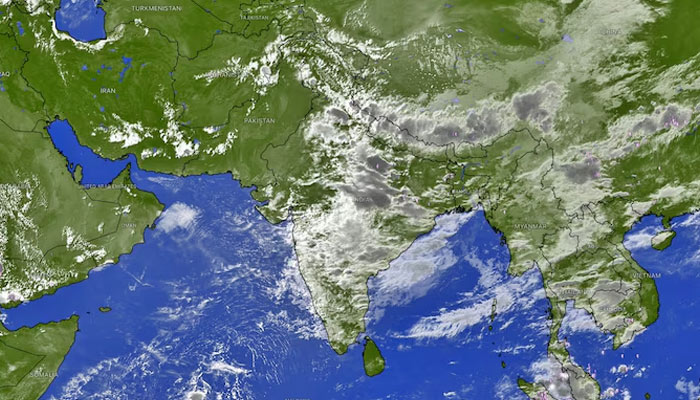
India’s southwest monsoon continues to advance unevenly, with the latest satellite imagery from the India Meteorological Department (IMD) revealing a striking divide in cloud cover even as rainfall activity shows signs of improving.
The INSAT-3DS satellite image captured on Saturday morning showed dense cloud masses stretching across western and central India, while large parts of northwest India and the Indo-Gangetic plains remained largely cloud-free, underscoring the patchy nature of this year’s monsoon.
According to IMD data, the country has received 395.5 mm of rainfall against the normal 446.3 mm since the start of the monsoon season, leaving India with an overall rainfall deficit of 11%.
While the national shortfall has narrowed significantly from the steep deficits recorded in June, rainfall remains unevenly distributed, with several northern and central states continuing to experience below-normal precipitation.
SATELLITE IMAGE HIGHLIGHTS MONSOON IMBALANCE
The satellite imagery showed an active weather system over western India, where a depression has been fuelling widespread rain across Gujarat and adjoining regions. By contrast, cloud cover over Delhi, Haryana, Punjab and much of Uttar Pradesh remained sparse and fragmented, reflecting weak monsoon conditions across northwest India.
Meteorologists expect the monsoon trough to gradually shift northwards, a development that is likely to revive rainfall across the region over the next few days.
NORTHWEST INDIA SET FOR RAINFALL REVIVAL
Beginning Sunday, Delhi, Haryana, Punjab and Uttar Pradesh are expected to witness light to moderate showers. However, rainfall is likely to remain scattered initially, covering only 20-30% of the geographical area, meaning many locations may not receive rain during the first phase of the revival.
A more substantial improvement is forecast between August 3 and August 5, when moderate to heavy rainfall of 40-100 mm is expected across Delhi-NCR, Punjab and Haryana. Rainfall coverage is projected to expand to 40-70% of the region, offering relief to areas that have recorded one of the weakest monsoon performances this season.
Meanwhile, south and central Rajasthan are likely to receive heavy rainfall on Sunday and Monday as the weather system over western India strengthens further.
Despite the improving outlook, meteorologists say truly widespread rainfall across northwest India may not set in until early next week. The delayed and inconsistent progress of the monsoon has created a stark contrast across the country, with flood-like conditions in parts of western India even as several northern states continue to grapple with persistent rainfall deficits.
The latest satellite imagery once again highlights the uneven character of this year’s southwest monsoon, with surplus rainfall in some regions and prolonged dry spells in others.
Comments are closed.